
The first Ordnance Survey covers were cloth-coated, and were intended almost entirely for general purposes. The remnant of this tradition survived until 1959 on Isles of Scilly, 1933. Such covers were issued on maps at scales from 25 inches to the mile to 25 miles to the inch. Many of these would have been issued in thin paper envelopes, some with Fisher Unwin's imprint. In Nos 1-3 below, “short” implies dimensions of approximately 100 x 160 mm, “tall” 95 x 180 mm
Reference numbers in square brackets and artists' initials are explained here
FORWARD TO NEXT SECTION: Covers designed for national map series
1 Textured red cloth
1.1. Title label, book-fold For use on colour-printed maps, 1897. Tall and short formats recorded
• 2 INCHES TO 1 MILE
[a] Open book 193x180mm. Heliozincographed at OS 1899.

• ONE INCH TO 1 MILE
- [a] Open book 217x160mm 1900 NSRC sheets 347-353 combined
- [b] Open Book 198x183mm 1898 NSRC sheet241 Also recorded on NSRO district maps with coloured main roads BRADFORD 1899,LEEDS 1899.


• 4 MILES TO 1 INCH
[a] Open book 185x173mm. 1899. 1/4 ". Kent.

1.2. Gold printing, adhesive Recorded only on engraved one-inch maps
- [a] 106x155mm epd June 1900 NSRO sheet 109 "ONE INCH TO A MILE"=52mm.
- [b] 107x158mm epd May 1900 NSRO sheet 84 "ONE INCH TO A MILE"=49mm


2 Central title panel, cloth, adhesive For use on engraved one-inch maps. With sheet name. Narrower covers also have adhesive series numbers: the maps in these are trimmed to the neatlines
2.1. Red
• ONE INCH TO 1 MILE
- [a] 94x154mm (Railways inserted to 1902) NSRO
- [b] 108x155mm 1898 NSRO sheet 52
- [c] 125x185mm 7.05 Four NSRC sheets mounted as one
- [d] 102x153mm. 1897(?) Second Edition Outline. Emarginate.
- [e] 115x176mm. 1903. RNSO brown roads District.


• 4 MILES TO 1 INCH
- [a] 86x176mm 1903 Outline with Blue water

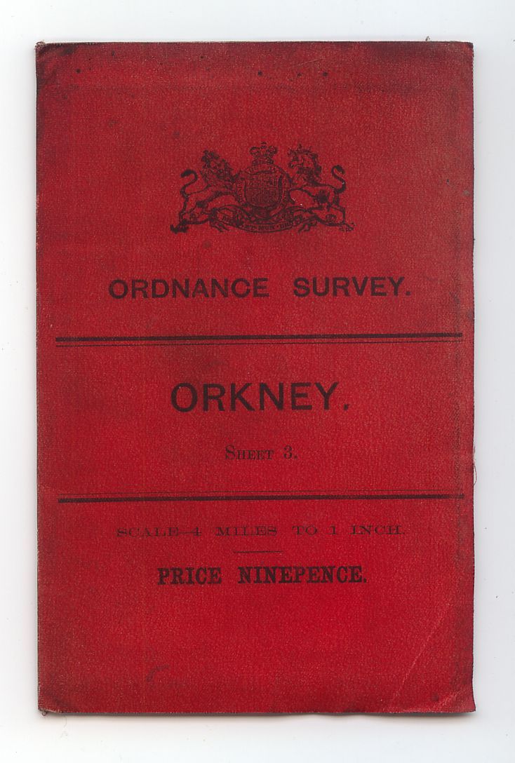
2.2 White
• ONE INCH TO 1 MILE
- [a] 104x179mm 8.05 NSRC
- [b] 110x179mm 1905 Third Edition Outline with Contours


• 2 MILES TO 1 INCH
- [a] half inch example is reported "Sheetlines" 88.p52.]
• 10 MILES TO 1 INCH
- 185x132mm. 12.11. Composite. Note arms of EviiR
. 
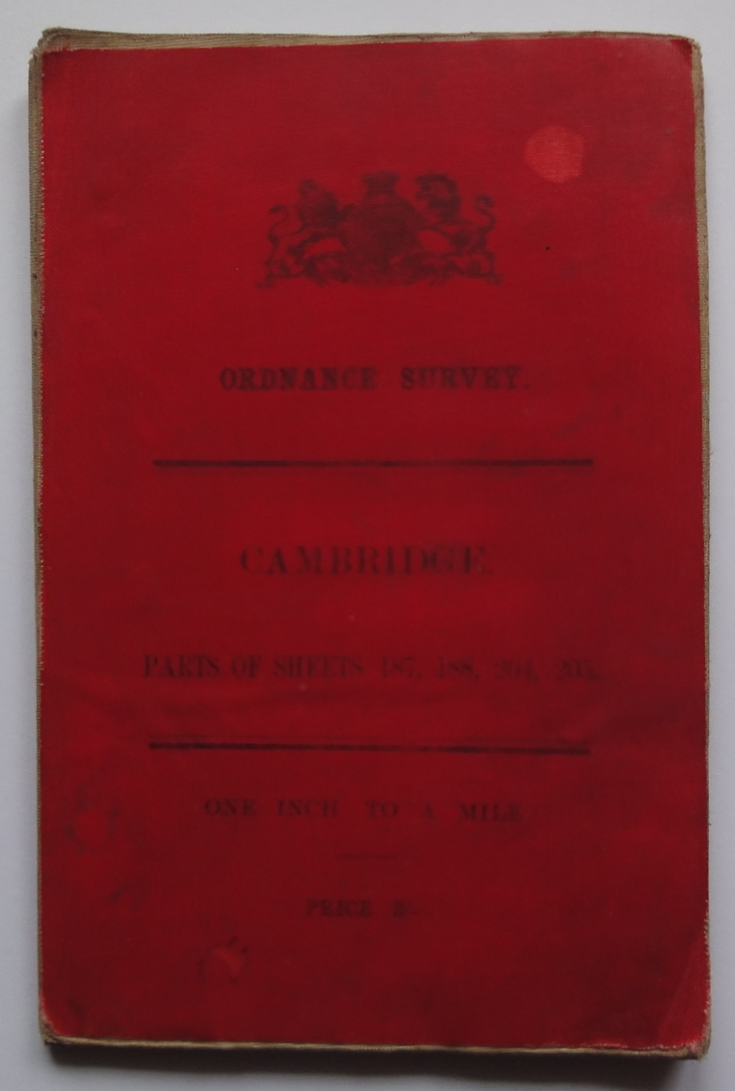
3 Title panel spanning cover Sheet name or series number titles used. Serif and sans serif lettering. Some covers (?printed in Dublin) have distinctive colours and arms
3.1. Short oblong
3.1.a. Red book-fold General purposes, c.1900
• SIX INCHES TO 1 MILE
- [a] Open-book 206x153mm 1903 The same bright finely woven cloth is commonly used on other H-03-1a covers, but this is the only 6" sheet recorded in this style? Arms of EviiR.

• TWO INCHES TO 1 MILE
• [a] Open book 206x159mm. 1902. Coarse dark red cloth, no "Rules For Ordering" on back. The change from bright red to dark red cloth seems to have occurred in 1904(?)

• ONE INCH TO 1 MILE
- [a] 103x160mm.RNSC 1899. Arms of VR.
- [b] Some covers were overprinted by OS for local stationers. Open book 210x160mm. RNSO coloured roads 1900.
- [c] Open book 210x160mm. RNSO coloured roads 1901.
- [d] 103x160mm. No print on back. RNSO coloured roads 1901.
- [e] 102x160mm. No print on back. RNSC 1902.
- [f] Open book 205x156. Ireland coloured 1903. Arms of EviiR,Rules for ordering on back with no interior letterpress as previously. Price altered by adding "AND SIXPENCE" The price rise from 1905.
- [g] 104x157mm. RNSC 1903. Price as from 1905 arms of EviiR Plain back with interior letterpress
- [h] 104x160mm. Ireland coloured 1904. Rules for ordering on back.
- [i] Open book 210x163mm. 3SSSC .Note coarser woven cloth and darker red colour. Price pre 1905 rise.


• TWO MILES TO ONE INCH
[a] Open book 205x159mm. Oxford SSS 1904

• FOUR MILES TO ONE INCH
- [a] Open book 210x157mm Reprint 500/1902. Arms of Queen Victoria.
- [b] Closed book 105x161mm. 1901. Outline with blue coastal tint and yellow roads. (The "County" map offered as the series sheet.)
- [c] Open book 210x157mm. Arms of EviiR. England & Wales 1st edition coloured 5.04.


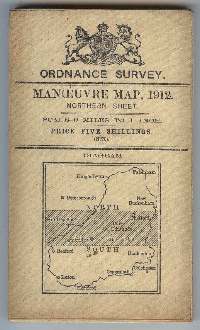
3.1.b. Red slip case Recorded only on half-inch Manoeuvre Maps, 1903
- [a] 100x173x10mm 1903 Four 1/2"SSS sheets headed SOUTH OF ENGLAND MANOEUVRE MAP (NORTH)PART OF SHEETS 61,62.70,71. (WEST) ditto 70,71,78,79,86,87. (EAST) ditto 71,72,79,80. (SOUTH) ditto 78,79,80,86,87,88,95,96,97. Unpriced slipcase presumably for military purposes.
- [b] Same but with PRICE for public sale


3.1.c Red cloth-hinged ?General purposes, c.1903; recorded mainly on Half-inch maps
• ONE INCH TO ONE MILE
- [a] 95x163mm 1903 RNSO with colored main roads. Arms of VR
. 
• 2 MILES TO 1 INCH
- [a] 96x160mm Railways inserted to 1903. Arms of EviiR. 1/2"SSS

• 4 MILES TO 1 INCH
- [a] 85x170mm. 5.04. 1/4" County (Beds, Cambs etc) Arms of VR..
- [b] 88x169mm 1901 Arms of EviiR. 1/4" County, First Ed with coloured main roads .
- [c] 86x167mm. 1903. Edinburgh District. Arms of VR.


3.1.d Book-fold, blue card Royal Parks: Hyde Park & Kensington Gardens [Twelve-inch map],1906 107x177mm

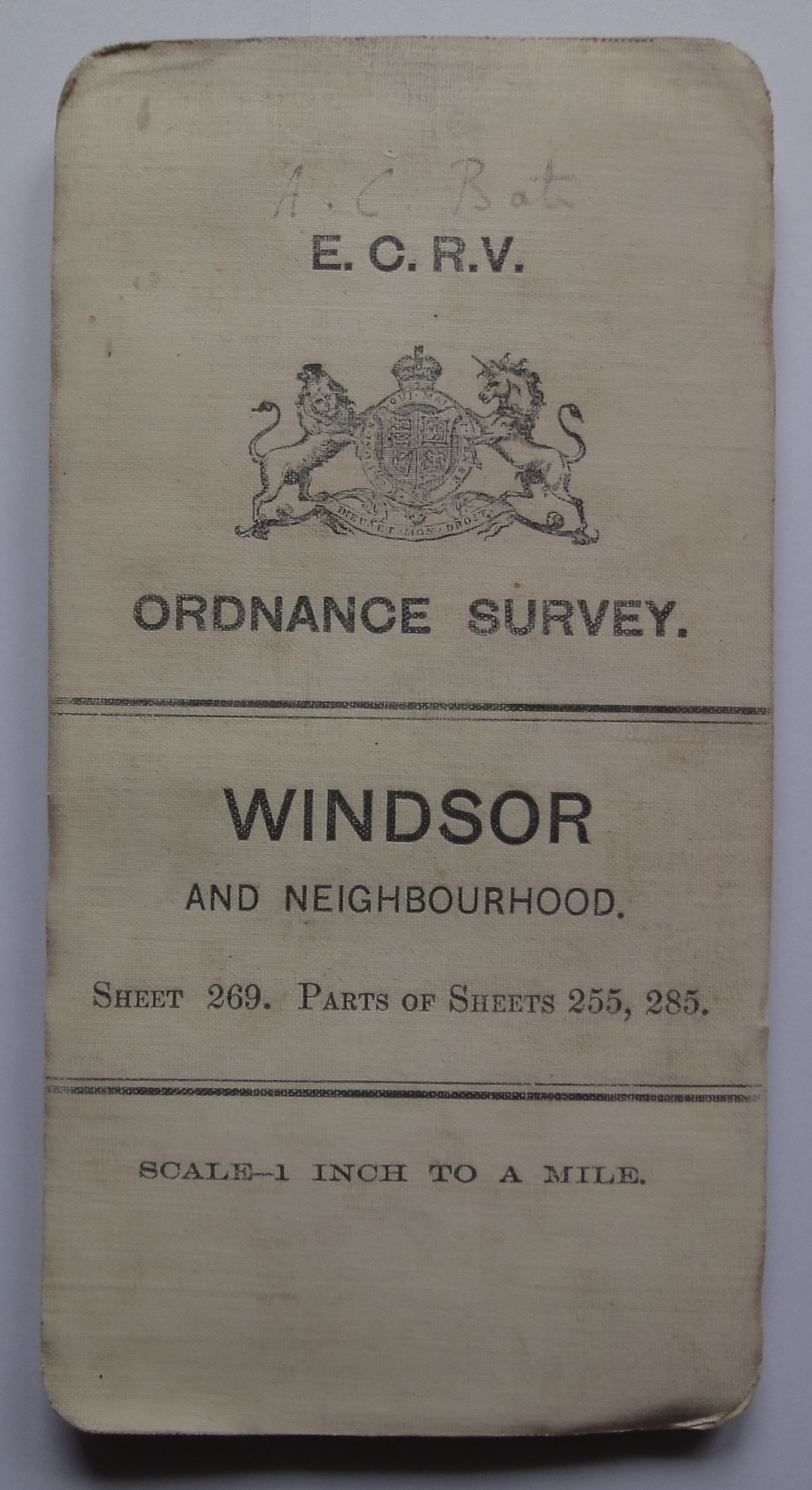
3.2 Tall oblong Some marked “W.D.” for “War Department”, or “P.S.: for “Public Service”
3.2.a.1. Red hinged General purposes, 1904
• ONE INCH TO ONE MILE
- [a] 95x183mm 3rd.SSSC 1905
- [b] Envelope 104x185mm flap missing.
- [c] 95x183mm 1906 Third SSSC.
- [d] 93x182mm. 1905. Scotland, Third, Coloured. Arms of VR.


• TWO MILES TO ONE INCH
- [a] 95x183mm 1905 SSS.

• FOUR MILES TO ONE INCH
- [a] 95x183mm 2.05 First.HS. cf identical map in H-03-2b1.
- [b] 95x183mm 1.06 1/4" Scotland
- [c] Envelope 104x185mm+ flap
- [d] 94x183mm 1905. Ireland
. 


3.2.a.2 Red book-fold General purposes
- [a] Open book192x183mm 1899 NSRC
- [b] Open book 236x182mm. 1904 RNSO sienna roads


3.2.b.1 White hinged [1] General purposes, 1906-c.1918. A 1:100,000 map of Metz, 1907 is recorded!
• 25 INCHES TO 1 MILE
- [a] 94x183mm 1923


• 3 INCHES TO 1 MILE
- [a] 105x183mm May 1911 Map title is "MAP OF THE COUNTRY ROUND SHORNCLIFFE, SHOWING THE AREA AVAILABLE FOR MANOEUVRING"

• 2 INCHES TO 1 MILE
- [a] 97x183mm. With horizontal hachures and yellow ground outside the WD area. 1908.
- [b] 96x182mm. 1-06 reprint of 3.1.a. 2".


• ONE INCH TO 1 MILE
- [a] 95x183mm 12.06 NSRC. Note title with Serif typeface and (NET) under PRICE.
- [b] The flattened envelope 115x190+40[flap]mm 12.08 For Ireland First coloured H-3-2b1. Note (NET) under PRICE
- [c] 95X183mm 5.06 Third SSSC Note PS for Public Service
- [d] 95x183mm 1907 Third LSS. Note WD arrow and (NET).
- [e] 95x182mm. 1907. 3SSSC Prepared specially for Eton College Rifle Volunteer Corps.
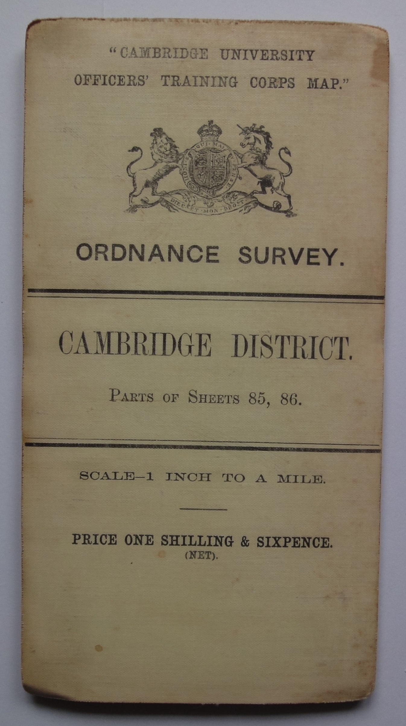
- [f] 96x182mm. 1910. 3LSSC. For Cambridge University OTC.
- [g] 95x185mm 1906 "SHEETS" in large print. [h] 97x183mm 7.08 "SHEET" in small print.


• 2 MILES TO ONE INCH
- [a] The flattened envelope 115x190+?(flap missing)mm
- [b] Map 95x183mm 1906 HS solid green woods.
- [c] 97x183mm. 1908. Map with Layers,Hill Shading and Green Tree Symbols.


• 4 MILES TO ONE INCH
- [a] 95x183mm 2.05 First.HS. Note (NET) cf identical map in H-03-2a1.
- [b] 94x183mm 10.06. Scotland.
- [c] 94x183mm 4.07. Ireland.


• 10 MILES TO ONE INCH
- [a] 96x183mm 3.14. First arms of GvR

• 1:100,000
- 182 x 95mm, 1907. Map title "Environs of Metz".

• 1:600,000
- 182 x 95mm. 1907, Map title "Position of German and French armies 31st July 1870"

3.2.b.1 Overseas
- [a] No details known
- [b] 95x182mm. G.S.G.S.No. 2639. Southampton 1913.
- [c] 104x183mm G.S.G.S.No.2459 OSO,Southampton,1913.


3.2.b.2 Location map added England & Wales half-inch Manoeuvre Map, 1909/1910/1911/1912 (See 6.[o][p])
- [a] 96x183mm 1909 L.GTS.
- [b] 100x183mm 1911 L.Black Trees.
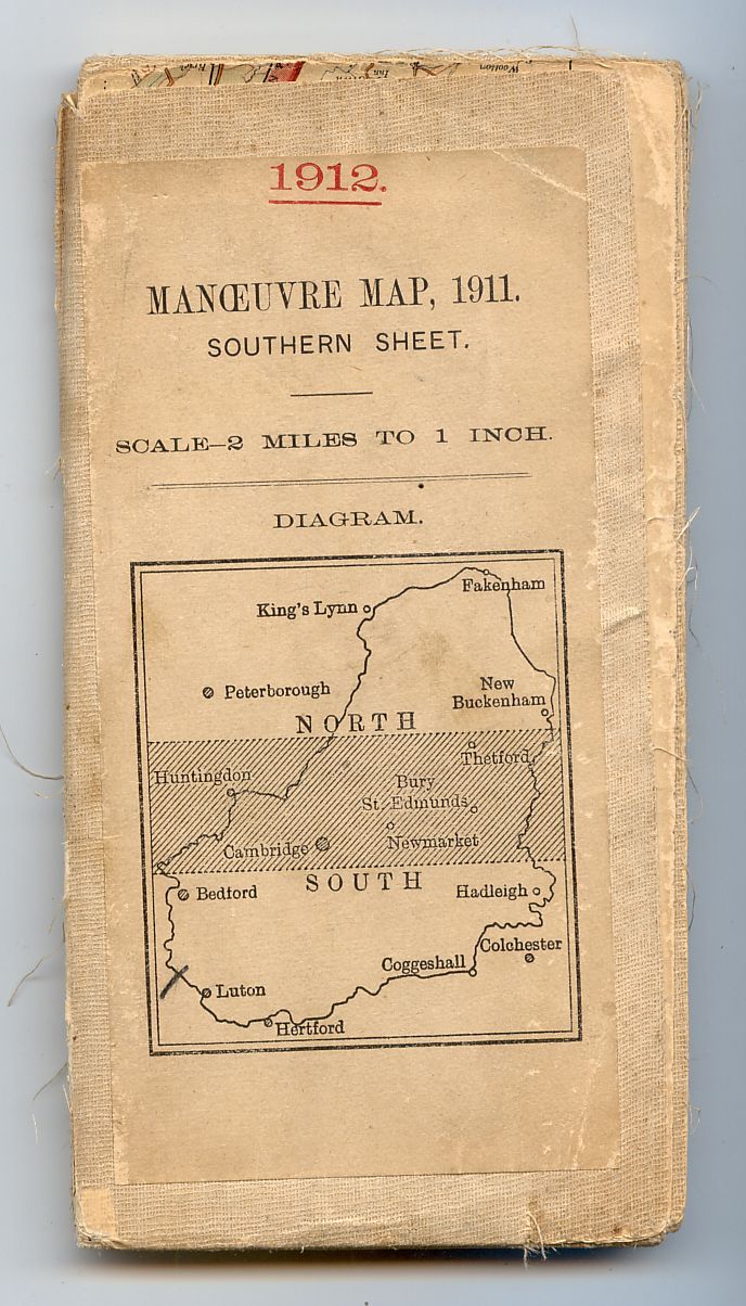
- [c] 100x182mm. The 1911 manoeuvres were postponed until 1912, most 1911 maps have a label inside "For--1911 read--1912". Note this is a sales copy with "PRICE---(NET)." beneath "SCALE--".
- [d] 104x178mm. Adhesive. The map mounted in sections and titled "MANOEUVRE MAP. 1912."


3.2.b.3 White book-fold General purposes
- [a] Open book 190x183mm 1900 NSRC.
- [b] Open book 193x183mm 1902. (NET). Extra text at bottom of Rules for Ordering.


3.2.b.4 White adhesive [1] General purposes: originally for dissected maps. Dimensions variable
• 6 INCHES TO A MILE
- [a] 118x156mm Emarginate but Edition of 1910
- [b] No date, margins trimmed composite, four sheets.


• 2 INCHES TO A MILE
- [a] 112x186mm 1902. First arms of GvR.

• ONE INCH TO 1 MILE
- [a] 105x180mm (November 1907) Third SSO. Dissected. Note (NET).
- [b] 109x175mm 1909 Third Edition Outline Dissected. Note (NET).
- [c] 104x165mm
- [d] 92x183mm 8.07. The paper map is mounted on a cloth "TRENCH MAP" 51c.SE2. The covers printed on the backs of other obsolete maps.
- [e] 110x180mm April 1912.Dissected 3rd.Outline
- [f] 185x100mm. Margins trimmed so no date. Third edition LSS. sheets or part of sheets 42,43,44,50,51,52,60,61 dissected 66 panels.


• 2 MILES TO 1 INCH
- [a] 97x180mm 1912 Cloth.
- [b] 103x181mm (1910-1914) L.Black Trees. Emarginate, centered on Aldershot.
- [c] 96x180mm 1918 HS. A Layered copy of this sheet without the(LAYERS)overprint(see[c]above) noted with "PRICE THREE SHILLINGS(NET)"
- [d] 182x105mm. 1909. Sheets 20,21,26 and pt 15 Cardiganshire, Carmarthenshire and Pembrokeshire, hill shaded
. 


• 4 MILES TO 1 INCH
- [a] 84x173mm. 11.19. First arms of GvR. Note small size and tall OS.

• 10 MILES TO 1 INCH
- [a] 103x178mm 2.07.Arms of EviiR
- [b] 104x179mm 2.07. First arms of GvR.


3.2.b.4 Overseas
- 193x115mm. OS cover on none OS map. ANWB atlas,24 panels mounted as an emarginate sheet
. 
3.2.c Direct printed covers For military use [2]
- [a] 95x176mm Further revisions by W.D. 1914. Third Edition (Coloured). Note first arms of GvR (1910).

3.2.d Irish coloured adhesive
- [a] 95x179mm 7.21 [
- b] 96x185mm Adhesive 1918


4 Location map, white For use on small-scale series/district coloured/outline maps, 1910
4.1 Hinged General purposes
ONE INCH TO 1 MILE
- [a] 97x183mm 1.12. Third LSS. Untitled map,actually Sheet 42 of the LSS. Also recorded with cover title Colwyn Bay District.[b]
- [b] 97x183mm 1.12. (See [a])
- [c] 8.11 Third LSS Paper
- [d] 97x182mm. Scotland. Third edition 1.12.
- [e] 6.12 Third Ed. Coloured. Also recorded with first arms of GvR.
- [f] 97x183mm 12.12 Third Ed. Coloured. Note first arms of GvR.
- [g] 90x180mm 2.11. 10.12. 9.14. Third LSS.85
- . [h] The flattened envelope 125x190+? (flap missing) mm 1908 Third LSS Note T FISHER UNWIN. [i] 122x194mm 1913. Similar oversized covers are used on ORKNEY(NORTH)and the two SHETLAND sheets one of which dissected 128x200mm.


• 2 MILES TO 1 INCH
[a] 97x183mm 1911

4.2 Adhesive General purposes: originally for dissected maps. Dimensions variable
- [a] 108x179mm 10.12 Third LSS Dissected. Original price TWO SHILLINGS & SIXPENCE.

4.3 Direct printed covers For military use [2]
• ONE INCH TO 1 MILE
- [a] 97x182mm 1914 Popular with Layers Hachures and Contours.
- [b] 96x177mm 10.10 Third LSS
- [c] 110x176mm 5.12 Third LSS Note "ENGLAND" usually & WALES.
- [d] 137x200mm 6.12 Third LSS. The map folded 6x3 panels instead of the usual 8x3. ([b] above)
- [e] 97x174mm. 1914. Small sketch. Popular 144, with Hill Shading "FOR OFFICIAL USE ONLY".


• 2 MILES TO 1 INCH
- [a] 96x179mm 11,1912. Only recorded H-4-3 paper map?

FOR FULL SET OF DISTRICT TITLES SEE SEPARATE PAGE
5 Series number or sheet name Direct printed covers, or via a label [2]. For military use at home and abroad
• 210 FEET TO 1 INCH
- [a]182x355mm 3000/10/43 C.

• 400 FEET TO 1 INCH
- [a]136x332mm 1904

• 6 INCHES TO A MILE
- [a] 178 x 104 surveyed by a field survey section O.S. 1910 Printed 1911 GSGS 2558 for WD purposes only.

• 2 ½ INCHES TO 1 MILE
- [a] 120x188mm. 1917.
• ONE INCH TO 1 MILE
- [a] 96x178mm 6.07 Third Outline with coloured main roads.
- [b] Map folded to 97x192mm,label 93x72mm 1913 Third.
- [c] 101x198mm. 1907. 3SSSC, Prepared specially for Eton College Rifle Volunteer Corps. (3.2b1.1",[e], not as may be expected 7.1a.1",[b].)
- [d] 97x183mm. Adhesive. Coloured with hachures for civilian use 1904, this the 5.18 reprint (the MV.1913)


![]()

• 4 MILES TO 1 INCH
- [a] 100x178mm September 1914 Second LSS Paper map,also recorded on cloth 1915 with title 1/4" ENGLAND. SHEET 1.
- [b] 100x178mm. 11.06. Ireland.
- [c] 87x178mm. 10.06. Scotland.
- [d] 135x196mm Late use of the style.


• 10 MILES TO 1 INCH
- [a] 97x177mm. 1.14. Great Britain

Repayment Maps
[a] 101x203mm. For "Weaver Navigation" 1922
[b] 135x196mm. For "British Association" 1938 Late use of the style.See also 255.


5 Overseas
- [a]99x186mm GSGS 2517. 1912 1:380,160
- [b] 116x183mm GSGS.3026 OSO.1915
- [c] 85x144mm GSGS.2740 October 1917 [
- d] 112x158mm GSGS.3952 November 1917 (CAMBRAI)


6 Index diagram Direct printed covers, or via a label [2]. For military use at home and abroad
• 2 ½ INCHES TO 1 MILE
- [a] 116x178mm. 1914.
- [b] 118x179mm. 1917
- [c] 122x175mm. June 1917. GSGS.No.3036.
- [d] 124x185mm 1915 G.S.G.S. 3036.


• 1 INCH TO 1 MILE
- [a] 97x165mm 1918 Third Edition Coloured. Note price in red.
- [b] 88x178mm 1911 Third.
- [c] 97x175mm. 1915. Third Edition outline with red contours and " MILITARY PURPOSES ONLY"


• 2 MILES TO 1 INCH
- [a] 100x179mm 1.13. HS.GTS
- [b] 95x182mm 1914. Outline with blue water and brown contours. Paper.
- [c] 88x177mm. 1913.
- [d] 95x178mm. 1912
- [e] 98x177mm 1912.
- [f] 98x183mm 1914.
- [g] 101x175mm 1914.
- [h] 98x177mm 1916
- [i] 95x152mm 1914. Serif title, map folded 8x4.
- [j] Label 79x160mm. North. (See 3.2b2.)
- [k] as [j] South.
- [l] 99x176mm. 11.15


• 4 MILES TO 1 INCH
- [a] 106x178mm 1916 Second Edition.
- [b] 100x165mm 8.14 Second Edition


6 Overseas
- [a] 99x167mm GSGS.2634 WO,1911.
- [b] 111x177mm GSGS.2526 OS,1911.
- [c] 106x178mm GSGS.2364 WO,1912.
- [d] 111x163mm GSGS.2742 MV.1914
. 


- [e] 110x169mm GSGS.2364 "PROVISIONAL EDITION" MV,1914.
- [f] 101x177mm GSGS.2738 OSO,1914.
- [g] 100x160mm GSGS.2738 OSO,1914.
- [h] 97x187mm. GSGS2097, OSO 1915.
- [i] 107x177mm GSGS.3110 OSO.1915.


-SKOPLJE(all).JPG)
- [j] 111x169mm GSGS.2743 OSO,1915
- [k] 106x178mm GSGS.2364 OSO.1915.(MV.1915 see [e] above)
- [l] 111x171mm GSGS.2743 OSO,1915.
- [m] 108x169mm GSGS.2733 WO.Feb.1915.Revised Edition.


- [n] 112x170mm GSGS.2742 EDITION 3. OS, 1916.
- [o] 108x177mm GSGS.2364 2nd.EDITION WO April 1916.
- [p] 112x168mm GSGS.2742 "TRENCHES CORRECTED TO 15-8-16." OS, 1916.
- [q] 112x160mm GSGS.2743 OS,May 1917.


- [q] 111x162mm GSGS.2742 "TRENCHES CORRECTED TO 4-3-17." OS, April 1917
- [r] 111x159mm GSGS.2742 "TRENCHES CORRECTED TO 8-3-17." OS, March 1917.
- [s] 109x180mm GSGS.2321 "Printed by the Survey of Egypt, under Authority from the War Office. 22nd Jan.1917"
- [t] 116x168mm GSGS.3062 "TRENCHES CORRECTED TO 7-2-17." OS, February 1917.


.JPG)

7 "Ordnance Survey" redrawn Mostly on adhesive covers: post-1924 issues use the “Official” Royal Arms
7.1.a. Location map, white cloth For use on small-scale series/district coloured/outline maps, c.1918
• 1 INCH TO 1 MILE
- [a] 107x178mm Adhesive/Dissected 12.13 Third LSS. (BOE).
- [b] 93x182mm. Hinged. 1913. 3LSSC. "Prepared specially for Eton College Officers Training Corps" ( See also 5.1",[c] & 3.2b1.1",[e] .)]
- [c] 95x177mm Adhesive 1911 Third Outline with coloured main roads.
[d] 107x178mm. Adhesive/Dissected . As [c] but print code 4.20. and sketch for Leicester District.


• 4 MILES TO 1 INCH
- [a] 96x177mm Adhesive 1914 Second
. 
FOR FULL SET OF DISTRICT TITLES SEE SEPARATE PAGE
7.1.b. Title panel, white cloth [1] General purposes, c.1918. A surprisingly late example of it is recorded on South Central [Quarter-inch District Map], 1924
• 1:500 (about 10ft to a mile)
- [a] Marbled ends 148x242mm(original OS cover?)99x136mm Reprint 50/1901.

• 10 INCHES TO 1 MILE
- [a] 102x176mm. Heliozincographed 1920. Parks coloured in green.

• 6 INCHES TO A MILE
- [a] 104x178mm Adhesive 50/08.
- [b] 105x192mm. Adhesive. Edition of 1909, 150/11
- [c] 96x183mm. Hinged. Published in 1903
.


• ONE INCH TO A MILE
- [a] 97x172mm Adhesive 1903. Third edition
- [b] 95x177mm Adhesive (Cloth map,faint title panel lines 36mm apart) 1907 Third Outline with coloured main roads. Also noted wih Paper map
- [c] 109x176mm. Adhesive, 1906 3SSO.


• 4 MILES TO 1 INCH
- [a] 112x180mm Adhesive (Cloth map) 1924 Third coloured with layers. (Used for training in the Staff College [Hellyer"Small Scale Maps"-1999])

• 10 MILES TO 1 INCH
- [a] 98x186mm Adhesive (faint panel lines 47mm apart) 3.14. Coloured. Also noted SHEET 7.8 (combined) 94x177mm, faints at 38mm Adhesive 5.09. & SHEET 11 97x183mm faints at 41mm Hinged. 1-14.
- [b] 107x178mm. Adhesive. 1904 reprint 11.16
- [c] 135x185mm. 1904 (railways revised to 1910, Composite map. Second arms GvR. See also 2.2. 10 Miles.


• 25 MILES TO 1 INCH
- [a] 107x178mm Adhesive/Dissected 8.14. 2ND. EDITION 1912

7.2.a. Location map, buff card Mostly recorded on one-inch outline District Maps with sienna roads, c.1921 [17]
• ONE INCH TO A MILE
- [a] 97x177mm Adhesive (Cloth map) 7.21. Third Outline with coloured main roads. Note first arms of GvR (1910).
- [b] 97x179mm (Paper map) 7.21. Third Outline with coloured main roads. Note second (1920?) GvR arms also used by Arthur Palmer on H.14,34,45 & 64. Also compare with other H.7.2a TORQUAY and 2b's HITCHIN and TAUNTON.
- [c] 99x177mm Adhesive 9-20. NSRO with coloured main roads. Note GvR (1924) official arms.
- [d] 180x108mm. 1904. Third edition, brown roads.


• 2 MILES TO 1 INCH
- [a] 87x163mm. Margins trimmed no date.
- [b] 90x162mm. No date, trimmed to neatlines.


• 4 MILES TO 1 INCH
- [a] 96x175mm. Adhesive. 1913. First arms of GvR. Second edition coloured.
- [b] 96x177mm. Adhesive. 8-14. Second arms of GvR. Second edition coloured.


FOR FULL SET OF DISTRICT TITLES SEE SEPARATE PAGE
7.2.b.1 Title panel, buff card [1] For maps lacking individually styled covers, c.1921. Special maps include: Taunton [One-inch Popular Edition sheets 120/129 conjoined], c.1924, Royal Parks (Richmond Park) [Ten-inch map], 1926
• 12 INCHES TO 1 MILE
- [a]100x177mm Adhesive 1923.

• 10 INCHES TO 1 MILE
- [a] 98x176mm Adhesive 1926

• 6 INCHES TO A MILE
- [a] 109x189mm Adhesive EDITION OF 1919
- [b] 114x152mm. Adhesive. No date trimmed to neatlines.
- [c] 105x179mm. Adhesive. Edition of 1914 composite 4 sheets


• ONE INCH TO A MILE
- [a] 107x179mm Adhesive/Dissected Railways inserted to October 1910. Third SSSO
- [b] 107x179mm Adhesive/Dissected Minor corrections October 1912. Third SSSO
- [c][d] Both 96x176mm Both 1-21. Popular. (See also 8.2)
- [e] 95x177mm 5000/27. (See 7.2b3)
- [f] 107x180mm 500/29. Note no price statement!
- [g] 108x175mm. 102, 1000/24. 103, 500/28. Composite mounted side by side.


• 2 MILES TO 1 INCH
- [a] 109x187mm Adhesive 1914 Third HS Comprising Sheet 10 and the lower 1/3rd of Sheet 7.

• 4 MILES TO 1 INCH
- [a] 100x176mm. 10-06. First edition, coloured.


• 1:1,000,000
- [a] 2750/28.

7.2.b.2 Large landscape format Six-inch sheets
- [a] 277x200mm Adhesive Reprint 50/25. "EDITION OF 1912 LANCASHIRE.SHEET LXXX.N.W."
- [b] 276x199mm. Adhesive. Reprint 50/26. "SECOND EDITION 1904"
- [c] 276x203mm. Adhesive. Edition of 1926. HEET in "SHEET" same size as "N.E." and in Scale "A" replaces "1".


7.2.b.3 Large portrait format.
• 1:2500
- 150x242mm. Second Edition 1905. 30/10.

• ONE INCH TO A MILE
125x225mm Adhesive 1919. (See also 7.2b1 [e]).

8 "Official" Royal Arms Used on official publications from 1924. Enlarged, it was the feature on:
8.1 Single lineation on buff
8.1.a. Black arms and red
8.1.a.1 With location map One-inch England & Wales Popular Edition District/Tourist Maps, c.1927 [17] One-inch England & Wales/?Scotland Third Edition District Maps, c.1927 [17]
- [a] 99x176mm Adhesive 6000/30. "SPECIAL SHEET POPULAR EDITION" Note G enclosing v on arms.
- [b] 115x190mm Hinged 2500/32. Note the G enclosing v has been changed to E on the Arms. The 2000/25 printing has G enclosing v and is "Price:Four Shillings Net".
- [c] 107x189mm Hinged "EDITION OF 1921" The G not enclosing v. Presumably a late mounting of the map during the reign of George VI. (The only recorded use of H.8.1a1 on a Scotland third edition map?)


For full set of 'District' titles see separate page
8.1.a.2 No location map. See No 24 [8]
• ONE INCH TO A MILE
- [a] 110x192mm Hinged 3500/31. "SPECIAL SHEET POPULAR EDITION" Also recorded in the standard H.8.1a1 cover.
- [b] 104x192mm Hinged 8,000/30. "PARTS OF SHEETS 30.36." (Popular) Also recorded in the standard H.8.1a1 cover.
- [c] 109x192mm Hinged 4000/29. "TOURIST MAP" (Popular coloured with layers) The cover is subtly different to the others in this group with the addition of the short waved line under the title. The 9500/31. printing has standard H.8.1a1 cover.


• 2 MILES TO 1 INCH
- [a] 111x196mm Hinged 10,000/34. "Special District(RELIEF)Map." No v in G on arms. The same map is recorded with the v, another copy with the v and Net after the price.
- [b] 118x195mm. Benderfold. 10,000/34.
- [c] 103x191mm Hinged 4000/32. "Special District(RELIEF)Map." Also recorded without v in G and Net after price.
- [d] Folded 119x199mm Bendefold 30/37 M.37 R.36 "Special District(RELIEF)Map." No v in G. Now clearly a map printed during the reign of George VI. Also seen with "Price Three Shillings" This printing of the map is also recorded with hinged cover without v or Net.


8.1.a.3 Black and Black
93x171mm Adhesive 250/29. An outline printing of the 1920 Wirral Footpaths map with a blank paper cover over the footpath details and a PHILIP etc.label covering the Published by Wirral Footpaths section.

8.1.b. Red arms and black Isles of Scilly [Two-inch Special District (Relief) Map], 1933 [7]
- [a] 111x192mm Hinged 10000/33. "Special District(RELIEF)Map." The 20/37 printing drops v in G and Net after Price.
- [b] Folded 116x195mm Benderfold 3261 "Special District(RELIEF)Map." No v in G but Net after Price.
- [c] Folded 116x195mm Cloth Benderfold 3261 "Special District(RELIEF)Map." Not an H.8 it bears the arms of George VI but illustrated here because the design is otherwise identical.Also recorded on paper maps 3/6 Net and 4/- Net
- [d] Arms of EiiR.


8.1.c Black on Buff Single lineation
• 1:25,000
- [a] 297x200mm Emarginate but v deleted from G in arms so post 1937.
- [b] 230x253mm. MV, Jan 1949.
- [c] 200x99mm. Emarginate. (see 221.1 with arms of GviR)
- [d] 203x99mm. As [c] but alpha/numeric Sheet reference.


• ONE INCH TO A MILE
- [a] 200x302mm Adhesive (1947) Emarginate Dissected. With manuscript water companies, pipelines,boundaries etc
- [b] 326x237mm. Trimmed New Popular, huge map dissected 40 panels.


• 2 MILES TO 1 INCH
- [a] 131x178mm Adhesive "Revised to 1-4-49" Administrative/Parliamentary boundaries in colour on brown outline map OS 1938

• 1 : 1,500,000
- [a] 481x479mm 1924. 22 pages of maps printed on transparent paper + 4 coloured underlays in rear pocket. See also 8.3b4.[b]

8.2.a Waved lineation on buff [1] ?One-inch England & Wales/Scotland Engraved Black Outline Series [See No 80]
One-inch England & Wales/?Scotland War Revision/Second War Revision, 1940 One-inch England & Wales outline District Maps with sienna roads Taunton [One-inch Popular Edition sheets 120/129 conjoined], c.1928 [17] Marlborough [One-inch Popular (Special Edition, with Hills) sheet 112], 1931
• 6 INCHES TO A MILE
- [a] 90x179mm Adhesive 500/31. Outline.
- [b] 104x177mm Adhesive "EDITION OF 1915"
- [c] 140x211mm. Adhesive. Edition of 1920 50/29.
- [d] 128x201mm. 1924. Six quarter sheets composite centred on Malmesbury


• ONE INCH TO A MILE
Waved Border
- [a] 97x192mm. 3500/31. Standard Popular Edition sheet.
- [b] [c] 97x177mm Adhesive 3000/31. Note "Sheet" and "SHEET" and different texts under MARLBOROUGH
- [d] 85X175mm. Adhesive. Sheet 138, 5000/27 3300/31 Popular edition sheets 128 and 138. (See also 7.2b1. One inch [e] and 7.2b3.)
- [e] 148x196mm A combination of 3rd.SSO sheets 267,268,282,283,284,298,299&315 all emarginate,all 1910 or earlier. The cover 1924 or later. Produced only for Hampshire County Council?
- [f] 129x203mm. Adhesive. No date sheet 28, Part of sheets 27,33 popular edition outline. Catchment boundary overprinted in red. (See also 8.3b4. Six inch [b]}
- [g] 106x179mm. Adhesive. 1927. Note the same map appears in a similar cover at 256.1 also see below at 25 Miles to 1 Inch.


No Border
- [a] 193x110mm Hinged. 21,550/8/44.B
- [b] 109x193mm 20000/4/42LR. GS3907 Popular Edition Style
- [c] 110x 193mm Adhesive 1925. Note no price
- [d] 111x194mm. Bookfold.2650/34. Twelve sheets issued,84,85,95,96,106-108,114-116,124 &125..in 1934. (See also 8.3b2, 1")
- [e] 106x181mm. Adhesive.Part of sheets 46,47,54,55,63,64. Emarginate circa 1937.(formerly the property of "KESTEVEN COUNTY COUNCIL")


Barnicot & Pearce, Taunton
- [a][b] 94x177mm Adhesive 500/28. Popular (see also H.07.2b) Note different ampersands! (Was the 500 printing a special for BARNICOTT & PEARCE?)
- [c] 111x193mm Hinged 835. As [a][b] but now hinged with additional short line between Scale and Price
- [d] As [c] but without BARNICOTT & PEARCE footnote.
- [e] 108x204mm. 436. ER.


![]()

• 2 MILES TO 1 INCH
- [a] 102x176mm. Adhesive. Trimmed. Layered, catchment area boundary overprint blue pecked lined with blue shading.
- [b] 109x192mm. Adhesive. 500/30. Outline, catchment boundary as [a] river Nene and tributaries in red.


8.2.b Waved lineation on brown cloth
- [a] 135x222mm Adhesive 100.32 The two 4" outline maps conjoined and dissected.

8.3 Double lineation
8.3.a.1 Red on white paper Six-inch [black] Town Maps, 1931 [2]
- [a] 103x190mm Direct 1000/35. Outline. Also 1000/36
- [b] 108x178mm Direct 1000/32. Outline.
- [c] 103x190mm Direct 1000/40. Outline. No v in G.


For full set of titles see separate page
8.3.a.2 Black on white paper, 1936
[a] 107x183mm Direct 2536.Fourth Edition.SCOTLAND,SHEET 3" (Coloured) Note E not Gv on arms.

8.3.b Black on buff card/paper
8.3.b.1 Standard format Norfolk Broads [One-inch Special Sheet Popular Edition], 1932. See No 24 [8]
• 10 INCHES TO 1 MILE
97x174mm. 250/37. cf 7.2,b,1 10 Inches to 1 Mile.

• ONE INCH TO A MILE
- [a] 110x201mm Hinged 4050/32. "SPECIAL SHEET POPULAR EDITION"
- [b] No NET, price in manuscript, change of text below.
- [c] 110x188mm Hinged, . Popular Edition One -inch Map. War Revision 1940. Published at the War Office 1931. Sales copy. Price One Shilling & Sixpence. Revised Price 2/- net.
- [d] 122x210mm 1933. Also "Aldershot Command" and "Salisbury Plain"


• 4 MILES TO 1 INCH
- [a] 109x201mm Proof cover mounted on thick card 1932 written on back.
- [b] 113x200mm. 300/33. 400/35. 650/37.


• 10 MILES TO 1 INCH
- 115x205mm. 1539 M39 R39 1541
. 
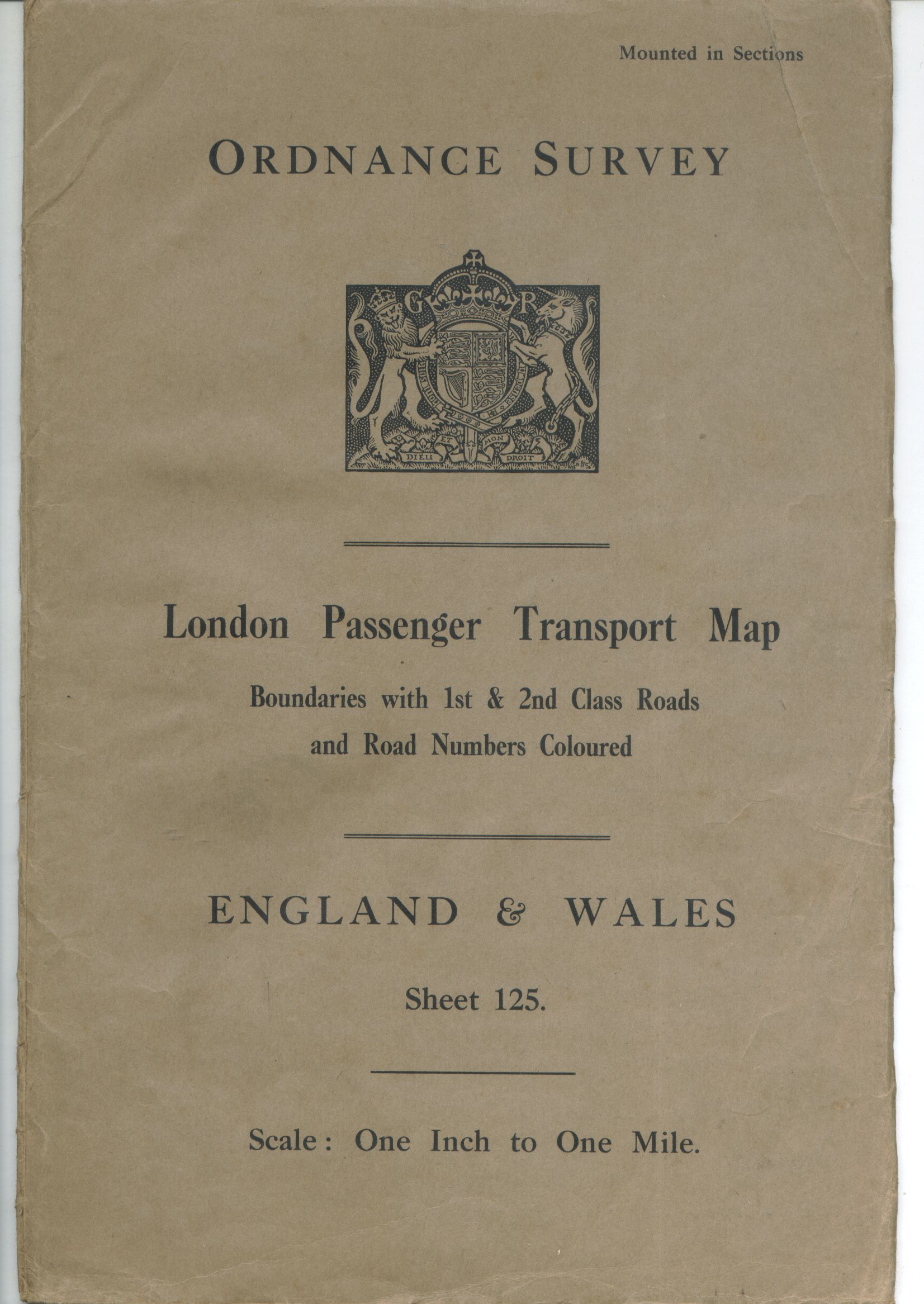
8.3.b.2 Large portrait format London Passenger Transport Map [One-inch Popular Edition], 1934
• ONE INCH TO A MILE
- [a] 199x300mm Bookfold 2650/34.(See also 8.2a. 1" No Border [d])
• 2 MILES TO 1 INCH
- [a] 286x414mm Adhesive 550/36. Parliamentary etc. Boundaries in colour on grey outline map. Note ER. Cover GvR 254x360mm also on 25inch to 1 mile "STAFFORDSHIRE SheetLVI.13"

• 6 INCHES TO A MILE
- 148x210mm. Edition of 1924 150/30 composite, 2 full sheets 4 part sheets.

8.3.b.3 Long format Main Roads of London [one-inch map], 1934 [published 1935]
- [a] 119x288mm Hinged 3000/34. Grey outline with red/black roads and green woods/parks. The folded map is also found in an envelope at the back of "Routes Through Towns" H.8.3d.
- [b] 119x286mm Hinged 3000/34. Title and lineage rearranged, v removed from G on arms.


8.3.b.4 Large landscape format Six-inch sheets; Agricultural Atlases
• 25 INCHES TO A MILE
[a] 278x204mm. Adhesive. "EDITION OF 1927"

• 6 INCHES TO A MILE
- [a] 277x202mm. Adhesive. "EDITION OF 1921". Upper case "SHEET" etc. in small type.
- [b] 278x202mm. "EDITION OF 1913" 50/30. Upper case "SHEET" etc. in large type.
- [c] 274x202mm. Adhesive. 50/31. "SECOND EDITION 1906" . Lower case "Sheet" but larger print size.
- [d] 278x203mm. Adhesive. 50/34. "EDITION OF 1910". Scale changes from "Six" to "6 ".
- [e] 251x202mm. Adhesive. 130/36. "EDITION OF 1921". Smaller type face for OS and reduced Royal Arms with "v" deleted from "G" also dashes in scale line.
- [f] 278x205mm. Adhesive. 150/41/W. "EDITION OF 1931". OS more compact,dashes revert to single colon.
- [g] 283x198mm. Adhesive. 50/45.Wa. "EDITION OF 1929" (EAST RIDING) added unlike [d] or 7.2,b,2.[a]
- [h] 275x202mm. Place named in brackets. Trimmed some marginal information reapplied but no date.
- [j] 150 x 230x150mm. 1913/1914. Composite, comprises 6 x 6" maps Sussex W Sheets X NW, XSW XNE XINW Hampshire XLIVNE XLIVSE XLV Surrey XLIV XLV Thames above Teddington Lock catchment area boundary shown with black pecked line this has been over coloured in blue pencil. (See also 8.2 One inch [i])


• ONE INCH TO A MILE
- [a] 231x152mm Adhesive (1910) Third SSSO Emarginate.

• 2 MILES TO 1 INCH
- [a] 240x180mm 1934. ER on arms. (Map is entitled The Parliamentary County, Municipal Boroughs, Urban and Rural Districts and Civil Parishes).

• 1 : 1,500,000
- [a] 480x477mm 1000-7.32. 25 pages of maps printed on transparent paper + 3 coloured underlays in rear pocket. See also 8.1c [a].

8.3.c Ansell-fold maps [9]
8.3.c.1 Turquoise boards Road Map of Great Britain [ten-mile map], 1932/1935 [published 1937]
- [a] 222x190mm Adhesive 5000/32.
- [b] 241x190 Adhesive 2536. ER and price rise to 7/6 Net.

![]()
8.3.c.2 Brown boards Fully Coloured Map of Great Britain [ten-mile map], 1932 [17]
- 235x196mm Adhesive (Emarginate but using the 1925 3 Sheet maps)

8.3.c.3 ?Blue boards ?Quarter-inch Map of Scotland, c.1932 [17]
8.3.c.4 Red boards 3-inch Map of London with Gazetteer, 1933
- [a] 185x252mm Adhesive 1933
- [b] 196x255mm 1933 Gold print on Red leatherette wallet containing Ansell-fold map and space for "Quarter Inch sheet of your own neighbourhood"


8.3.d Atlas, turquoise boards Routes Through Towns, 1934 [published 1935]
- 235x209mm O.S.O.-9019-2,000 136pp+prelims.

Reference numbers in square brackets and artists' initials are explained here
FORWARD TO NEXT SECTION: Covers designed for national map series