
FORWARD TO NEXT SECTION: Period Maps
Reference numbers in square brackets and artists' initials are explained here
71 Foliaceous border, magenta [unknown artist] Jersey [Two-inch map], 1914. Post-1924 issues use the “Official” Royal Arms
- [a] 97x176mm Adhesive 1914. First officially approved GvR arms, design of 1911.
- [b] 97x172mm Adhesive 2000/24. "Snowstorm" arms of 1924.
- [c] 109x192mm Hinged/Adhesive 2000/31. White rather than the usual buff card.


72 Mont Orgueil Castle JCTW Jersey [Two-inch map], 1933 [published 1934][?8]]
- [a]110x192mm Hinged 5000/34. No "Net"
- [b] "Net"
- [c] No "Net", no v after G.


73 Street scene with clock EM Six-inch [coloured] Town Maps, 1920
- [a] 110x197mm Bookfold+flap 1919. Title on sides. Fully coloured map.
- [b] 112x203mm Bookfold+flap 1919. No title on sides. Fully coloured map. H.73.[c] 110x193mm, Adhesive. 1922. Black title
. 


For full set of titles see separate page
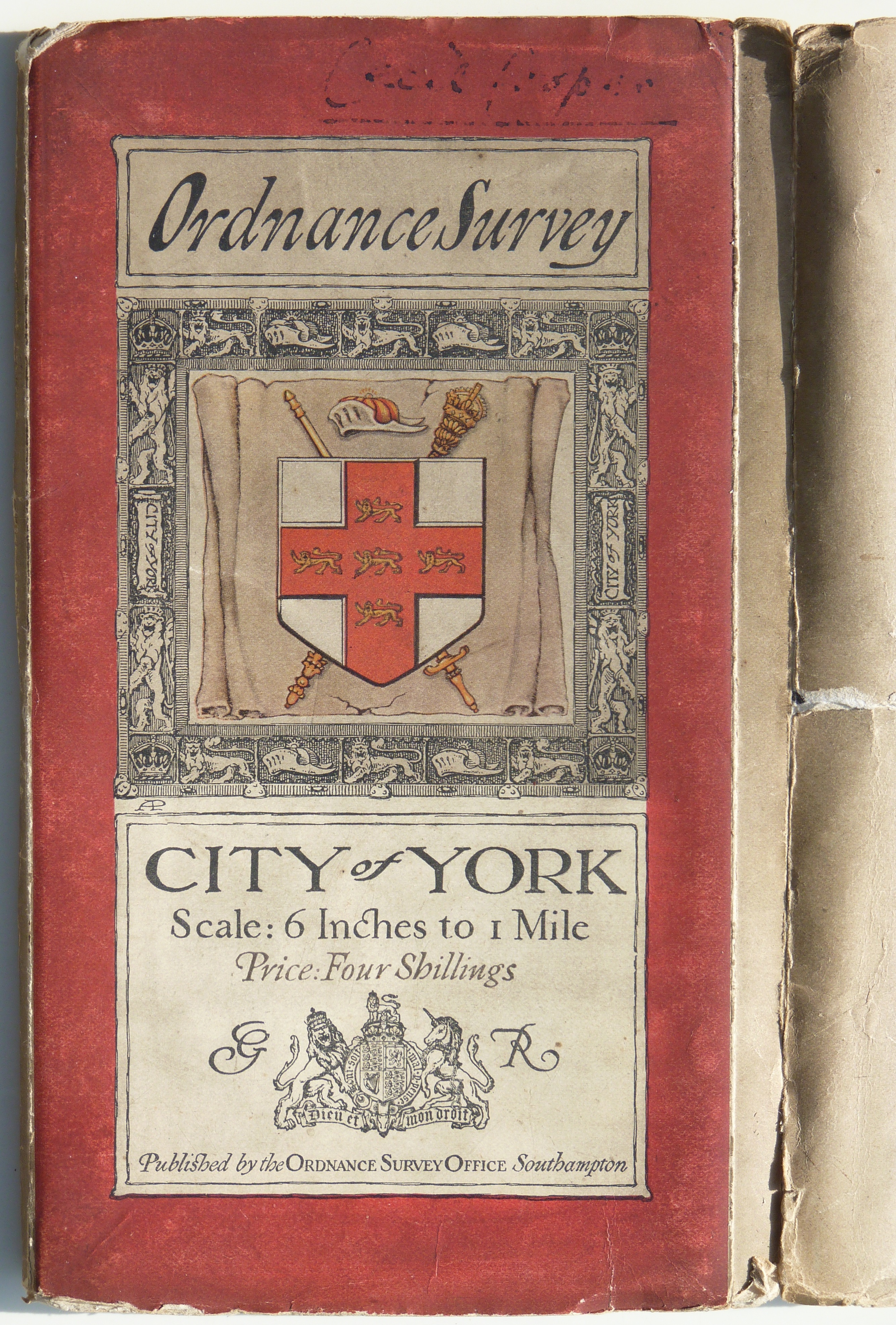
74 The arms of York AP City of York [Six-inch (coloured) Town Map], 1920, Bookfold+flap. Fully coloured map.
- [a] Artwork (or proof ?). Note 1920 under bottom right of shield border.
- [b] 112x199mm. Paper.
- [c] 112x203mm. Cloth. Also recorded without side titles.
- [d] Buff un-titled sides.


75 The River Thames at night: the view downstream from Hungerford Bridge EM London [Six-inch map], 1920 [17] - 20 sheets lettered A-T Central London: for the International Federation of Surveyors, 5th International Congress, Held in London, 18th-21st July, 1934
- [a] 145x210mm Bookfold 1920. Outline map with red contours.
- [b] 151x215mm Bookfold/Adhesive (The view cut down from the 6" cover). 500/34. 3" Coloured map of "Central London" + 6" Outline extract for Westminster.


76 Manx cat EJH Isle of Man [One-inch Popular Edition sheet 17], 1921
- [a] 96x177mm Adhesive 5000/27. "PRICE 1/6 Paper"
- [b] 96x176mm Adhesive 5000/27. "PRICE 2/6 Mounted" (cloth)
- [c] Open book 236x196mm Book/adhesive 4,000/34. Sheet number added top right. Lower case "Price"


- [d] 111x192mm Hinged 5500/31 This (cloth) printing also recorded in hinge/adhesive cover with "Price" but without "17".
- [e]119x202mm. Benderfold/adhesive 4038. No title on spine.


77 Trees with sun eclipsed EM The Solar Eclipse 29th June, 1927 [Ten-mile map]; cover title Eclipse Map
- 157x222mm Adhesive 5000/27. Also "Mounted in Sections Price 4/-" 159x225mm.

78 Scrollwork and highlanders EM Scotland [Ten-mile map], 1927
- [a] 128x229mm Hinged 3000/27. Price 4/- NET .Two lines of text at bottom.
- [b] 128x229mm Hinged 3000/27. Price 4/- NET .Three lines of text at bottom.
- [c] 125x228mm Adhesive 3000/27. Price 5/- .Three lines of text at bottom.


79 Scrollwork and compass EM A Plan of Part of the Town of Cambridge for the International Geographical Congress 1928. The design in colour was used on A Description of the Ordnance Survey Small-Scale Maps, 1930/1935/1937
- [a] 125x190mm Adhesive 12" Outline map with blue water and red title and conference buildings.
- [b] 158x245mm Booklet. Editions 7,8 & 9.


80 Lineation as H.8.2
- 1 The arms of Bristol {unknown artist] British Association Topographical Map for the Bristol Meeting 1930; cover title British Association Bristol Meeting 1930: Excursion Map 102x177mm Adhesive 3000/30. Layered map.

- 2 The Scottish royal arms {unknown artist] Dundee District 100x174mm. 1909. Third edition brown roads parts of sheets 56,57,48,49

81 St Paul’s Cathedral EM “3-inch” Map of London, 1933 – 4 sheets
- [a], [b], [c], [d] 118x187mm Bookfold 6000/33. GvR.


- [e] ER. Text under sheet name in upper case.

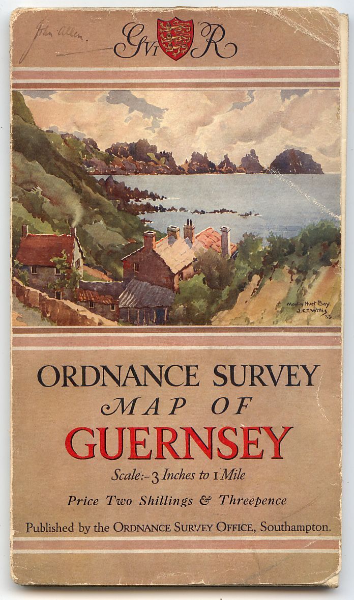
82 Moulin Huet Bay JCTW Guernsey [Three-inch map], 1934 [7] [?8]
- [a] 108x192mm Hinged 2100/34. GvR "Net"
- [b] 119x192mm. Hinged. 5000/34. GviR. "Net" deleted.
- [c] 113x195mm Benderfold 5,000/46. Cream background,No title on spine, GviR, "Net" deleted. Paper.
- [d] 112x195mm. 5,000/46. Titled spine.Cloth.
[e] 118x203mm Hinged Dissected map.


FORWARD TO NEXT SECTION: Period Maps